Wednesday, August 30, 2017

Tree Surgery...


We have a lot to be thankful for.

My friend reminded me that in some parts of the world, 
the flooding we have seen from Harvey 
would have caused loss of life in the thousands.  

In Houston, we have had loss of life, but barely reaching a dozen.  
Yes, yes, a dozen is way too many, but it is not hundreds, 
and it is not thousands.

For me, I am most thankful we are dry, and that all the family is safe.

I did have one inconvenience, but it wasn't much more than that.
I had a tree fall over onto my garage.  So, I called some guys to help.


Photo by Mark W. Laughlin

There's a garage under there...

Photo by Mark W. Laughlin
So, before he could start cutting, he needed to climb high, and rig some lines for his own fall protection, and to rig to branches, to lower them in a controlled way.


Photo by Mark W. Laughlin
He's not working out in a field, he's got house on all sides, so he carefully cut, piece by piece, dropping each one just where he intended to.
Photo by Mark W. Laughlin
Bit by bit...
Looking, planning, rigging, cutting...
Photo by Mark W. Laughlin
 It was so nicely done, it was like watching an artist painting a picture.

Photo by Mark W. Laughlin
Pieces positioned to cushion the fall of heavier pieces.

Photo by Mark W. Laughlin
All the branches off, and then the trunk...


Photo by Mark W. Laughlin
...until done.
Precisely done, no accidents, no drama.

Photo by Mark W. Laughlin
Skilled, equipped, insured.
Quite a professional job !

Eric Torres
JT Brothers Tree Service
Tel:  832-897-2820

Y'all take care !
-Mark


Saturday, August 26, 2017

Hurricane Harvey...


FINAL ( !!! ) UPDATE:
Noon Wednesday, 30-Aug-2017


Wooo Hooo !!!
The sun is out, skies over Houston and the Texas Central Gulf Coast are clear...
...and the ran has STOPPED !!!!
Unfortunately, this (damn) storm is still churning.
Now East Texas is getting it, then on to N. Louisiana and Arkansas.
We are not asking to give our water to our neighbors...
...but we are "not in a position to receive any further water at the moment..."
So, now we clean up and move forward.
Cada dia adelante !!
Many thanks again for the support of all our friends around the world !!
-Mark


UPDATE:
21:45 Monday (about 72 hours from landfall)

U.S. National Weather Service reports the center (of Harvey)
is now 55 mi (90km) east of Port O’Connor, Texas (see blue line)
Moving ESE (back out into the Gulf) at 3 mph. (that is very slow...)


At my house, we are just reaching the 30 inch mark (75cm in last 72 hours).
Rain was as least moderate all day today.
An additional 8-12” (20-30cm) predicted now through Tuesday midnight.


Local flood control reservoirs have reached capacity,
requiring release of water into already swollen drainage ways.
I can’t imagine how many homes must have water in them tonight.

-M


UPDATE:
05:00 Monday
Maybe...we're about done. (Maybe...)


Harris County Flood Warning Rail Gauges:
https://www.harriscountyfws.org/


My house is near the "24.08" in the lower-center of the frame.  My office is near the "24.00" at top-center of frame.  These are "inches of rain falling since the event began on Friday."  Yes...24 inches...60cm.  I've been around a long time now.  I saw more rainfall than that associated with a single storm...once.


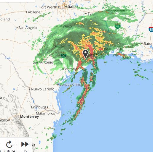
Storm circulation continues, believe it or not, now 55 hours after landfall, and it's a bad-case scenario because the storm's center is still near Victoria, (86.5 miles to SW), with the storm's "ass-end" continuing to linger out over the very warm, hurricane-producing waters of the Gulf of Mexico.  The long "feeder-band" you can see stretches out more than 600 miles (1000km) pulling in Gulf moisture (freakin' RAIN) like a big-ass fire hose.  


But, fortunately, as you can see from the mostly white area surrounding Houston, the destination for this water is shifting, however slowly, to the east.  Our buddies in Beaumont-Lake Charles will feel it today.  Heads up Eastern Friends...as the center of the storm moves out over water again, as expected today, re-strengthening is expected.  This will continue...


That's it for now.
- "Mark out"


UPDATE:
21:15 Sunday
Well, a little after 9pm Sunday, the Harris County Flood Warning Map says we've had 20.6" (52cm) rain at my house since rain began on Friday, about 46 hours ago.
The storm center is less defined now, but rotation continues (around the area of Victoria on the map), and you can see the rain bands streaming in from the Gulf are edging East of Houston (though the "Yellow-Red" shows you it's raining quite hard here at the moment).  It's not that we wish all this on our Louisiana brethren, but we can't keep taking it here !  ;-) 
- Mark


UPDATE:
05:30 Sunday

Storm still has formation, still has it's "legs" out over the warm water of the Gulf.
The "red dragon" continues to stream ashore...
My house has now received more than 12: (30cm)...and raining quite hard now.
There are two "High" Pressure systems, one to NW, one to NE, holding the now Tropical Storm Harvey on top of us. 

Landfall was about 11pm Friday, about 36 hours ago.
We've got at least another 36 hours of this rain to go...
Y'all hang in.
- Mark


Greetings !
It's about 5:30am Houston Time, Saturday morning..
Steady rain outside, but not much wind here in Houston.

The eye of Hurricane Harvey made landfall about 6 hours ago, near Rockport, Texas.
Eye now 133 miles (220km) southwest of Houston.  Rain getting heavier in the last couple of minutes.  Interesting thing, storm is still Category 1 Hurricane, and still very well formed, even though eye has now been over land for +6 hours.


The more difficult ting however, is speed...it doesn't have any.  I don't mean wind speed.  In fact it spun up rapidly as it approached the coast.  It was first predicted to make landfall only as a Tropical Storm, or maybe Category 1...but it pumped up to a 130 mph (210kph) Cat  4 before it hit land.


The speed I'm talking about, is speed of movement.  This photo from 08:00 Friday morning, 22 hours ago...moving only 7-8 miles per hour, and expected to slow down even more.

It  is likely to sit on us...
...and rain.

So, Connie, I hope you have power, it's coming right at you now.

Y'all take care,
- Mark


Wednesday, August 23, 2017

India, Kerala, Cochin Ferry


We have two or three ferries along the Upper Texas Coast, at Boliver, Lynchburg, Aransas. Each of those slightly larger than these at Cochin (aka Kochi).  The ones we have are almost always filled with vehicles, with just a few walk-on passengers.  These in Cochin are just the opposite...one or two small cars, a dozen motor cycles, and a hundred (or two) walk-on's.

Photo by Mark W. Laughlin


It's a short ride across the inlet. which connects the harbor area to the Arabian Sea in Southern India (same inlet lined with the Chinese Fishing Nets from the prior post).
Photo by Mark W. Laughlin

To get on is free, but there is a line, most people waiting 2-4 boats when traffic is busy.
Photo by Mark W. Laughlin
But there is a bit of shade, and a few vendors to make the wait easier.
Photo by Mark W. Laughlin
In comes the next boat...

As I saw it, there were two, constantly swapping places, 
back and forth across the channel, from about 6am till bedtime.


"Ok folks...pack it in, pack it in...plenty of room in the back !"
Photo by Mark W. Laughlin

The group is soon loaded and off they go...
Photo by Mark W. Laughlin

A few minutes ride, a moment to talk, 
take a photo, or just watch the water.
Photo by Mark W. Laughlin

And here comes the next boat...
Photo by Mark W. Laughlin


Ok, chop, chip...everybody off !
Photo by Mark W. Laughlin


We see what we wish to see.
I see color, energy, people living life.
What do you see ?
- Mark

Photo by Mark W. Laughlin


Sunday, August 13, 2017

India, Kerala, Kochi, Chinese Fishnets


I traveled a few days ago to a place in South India,
a place called Kochi, in the State of Kerala.
Photo by Mark W. Laughlin
One of the things you notice as you drive in, are these cool looking fishing nets.

Photo by Mark W. Laughlin
They are fixed to a pier on the shore.  They lower straight into the water and lie on the bottom.

Photo by Mark W. Laughlin
 When down, the tips of the four "spider arms" reach the water, and the net is out of site.

 Photo by Mark W. Laughlin
When the a-frame arm is tilted back, the net rises out of the water.
If there are fish in the net, they slide down to the part of the net fixed to the pier,
and to the guys waiting to grab them...

Photo by Mark W. Laughlin
 ...and to some of the "helpers" who want to see what "we" have caught.


Photo by Mark W. Laughlin
The Port of Kochi opens out onto the Arabian Sea, on the west side of the south part of India.  The fishnets line both sides of the inlet.

Photo by Mark W. Laughlin


This is one of my new favorite photos.  I say that for several reasons, first of course, I like the way it looks , the way it came out.  But more than that, I began to study it.  There is one a-frame that is horizontal on this first net, and a second one that is leaning back to the right, toward shore.  Pulling down on a rope on the shore-side a-frame starts the net tilting up out of the water.
Photo by Mark W. Laughlin


But study for a moment the large stones tied onto the ends of ropes, suspended from the shore-side a-frame. There is not one large stone, but many smaller ones, all on different length ropes.  As the shore-side arm tilts down, you need progressively less help from the counter weights, so , the first (lowest) weight comes down to rest on the pier, lessening the downward pull.  
Photo by Mark W. Laughlin
As the arm comes further down, progressive weights rest down on the pier, progressively reducing the pull of the counter-weights.  An ingenious, variable-mass counterweight system.  Totally cool !!


Photo by Mark W. Laughlin
Next, the small ferry, from which I was taking the net photos.

Y'all take care,
- Mark


Saturday, August 5, 2017

India, Gugurat, Champaner-Pavagadh Archeaological Park


I was in Vadodara, Gugarat, India over the weekend, so my friend Pankil asked if I'd like to see a few sites we hadn't previously seen.  This is an area not far from the Step Wells I had visited a year or so ago, but the Step Wells are about 1100 years old.  The buildings, city walls and mosques of the Champaner area date to about 1500, though they were built by some of the same Mogul emperor types that built the wells.  You can see a lot of similarity in the materials and craftsmanship.

https://writtenpost.blogspot.com/2016/03/sun-temple-of-gugarat.html
https://writtenpost.blogspot.com/2016/02/a-complete-step-well.html
https://writtenpost.blogspot.com/2016/01/anatomy-of-step-well.html

Photo by Mark W. Laughlin


Beautiful stone buildings with intricate carvings.

Photo by Mark W. Laughlin 
Photo by Pankil Shah 

 Twin minarets (and an old gringo)...


Photo by Mark W. Laughlin
Large internal area, heavy columns supporting the roof and upper floors.


Photo by Mark W. Laughlin 
 A smaller, shallower mini-step-well out back. 


Photo by Mark W. Laughlin 
Guardian of the temple (no tigers in this general area...)


Photo by Mark W. Laughlin 
Such intricate carving...think of the man(person)-hours it took to create.


Photo by Mark W. Laughlin 
My friend Pankil (Aaska's dad) to show the scale of the place.


Photo by Mark W. Laughlin 
Another mosque in the same area, a km or so away.  


The area is inhabited by the local folks whose ancestors have no doubt lived among the old buildings for many generations.  On a Saturday afternoon, they go about their business as always...
Photo by Mark W. Laughlin 

A lonelier part of the complex.  A ruined temple along the roadway that connects the park.
Photo by Mark W. Laughlin 

So, if you happen to be passing through Gugarat State, 
near Vadodara, stop in and see the park.  
Pretty Cool !

- Mark

https://www.tourmyindia.com/heritage/champaner-pavagarh-archaeolgical-park.html